environment
Type of resources
Available actions
IADC Research Activities
Topics
Keywords
Contact for the resource
Provided by
Years
Formats
Representation types
Update frequencies
status
Scale
-

Carbon flux and its isotopic signature in arctic regions under climate change (CarIsoA) Study carbon flux by evaluating CO2 assimilation on target species. Parameters: Light curve, CO2 curve and temperature curve for on Salix polaris, Saxifraga cespitosa, Dryas octopetala and Carex polaris
-

Continuous Vis-Near IR Characterization of snow-ice surface in Ny-Ålesund (SnowIceCReM) The activity foreseen for 2015-2020 includes: continuous full-range reflectance measurements; continuous multispectral observations; ground-truth survey on snow surfaces. The first part of the activity is attempted to replicate the experiment carried out in 2014 where a VNIR spectroradiometer were deployed at the CCT. Hardware upgrades will be coupled with the addition of some position and optical reference targets. An hemispheric webcam will acquire high resolution sky and ground images to support the experiment in terms of cloud and snow cover/roughness characterization, and to provide a quality check of the rotating support position by means of the above mentioned specific targets. The availability of such accessory information will help on selecting a homogeneous spectral albedo dataset. The same quality check approach will be used also for the deployment of a second instrument that will be developed in order to obtain fixed band albedo at 860, 1240 and 1640 nm. Both measurements will be hemispheric, in the 350-2500nm wavelength range. While the first set up obtains asynchronous spectral albedo, the second one provides synchronous spectral albedo on bands selected considering sensors deployed on satellites. The final task will be persecuted with a ground-truth survey focused on calibrating the two different hemispherical receivers with bidirectional observations.
-
ISotopic and physical-chemical MOnitoring of GLACial drainages and sea water in the Ny-Ålesund area (Svalbard) (ISMOGLAC) Sampling and in-situ measurements on snow and water, performed into both Kongsfjorden and glacial streams that originate in supraglacial, englacial and subglacial zones of different glaciers (Midtre Lovenbreen, Austre broggerbreen, Vestre Broggerbreen, Kongsvegen). Dataset concerns water isotopes signature of snow and Kongsfjorden water and physical-chemical data of the latter.
-
Isotopic characterisation of arcic ponds Sampling of ponds and surrouding terrestrial envionrment. matter (expressed as ash fry dry matter) and N content as a percentage in soil and lake sediment.
-

Contribution of Vegetation and Soil components to Carbon cycle in Arctic environment in relationship to climate change (VegSoCA). Measurements of soil respiration and 13C labelling on different species in the experimental field close to the CCTower using LiCOR LI-8100. Species were: Carex rupestris, Dryas octopetala, Salix polaris, Moss and bare soil. Dataset: Species type, date, soil water content, soil EC, soil temperature, CO2 flux.
-
Spatial variability: validation dataset on pops concentrations in snow (SVAL-POPS) We aim to measure the spatial variability of chosen persistent organic pollutants levels in the snow. The samples will represent three spatial scales: 2-5 m spacing, 0.5-1 km distance, and two sites across Svalbard: Ny Ålesund and Hornsund. These will be compared thanks to a laboratory crosscheck.
-
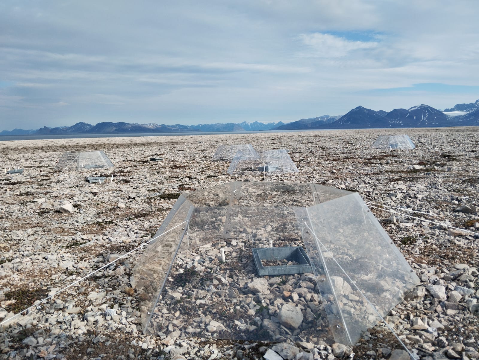
A long-term climate manipulation experiment has been ongoing since 2014 at the REMUS site (Responses of Microbes in Upper Soil Horizons to Environmental Manipulations). Twenty-four open-top chambers (OTCs) were installed to simulate warmer ground temperatures and increased precipitation. To mimic enhanced rainfall, irrigation is applied twice a year, at the end of June and August. The transparent OTCs create an average ground temperature increase of approximately 1°C in the treated plots. The site is located about 11 Km from Ny-Ålesund at Kongsfjordneset (78.96661°N 11.47576°E) on the Brøgger Peninsula. In total, 48 plots with different plant species have been selected for the study. Of these, 24 are equipped with OTCs, while the remaining 24 are irrigated, with half of the irrigated plots also containing OTCs (12 with OTCs, 12 without). The REMUS site is registered on the Research in Svalbard Portal under ID 6921. This site is part of the International Tundra Experiment (ITEX), a global research initiative aimed at understanding the responses of tundra plant species through simple manipulation and transplant experiments conducted across multiple Arctic and alpine sites.
-

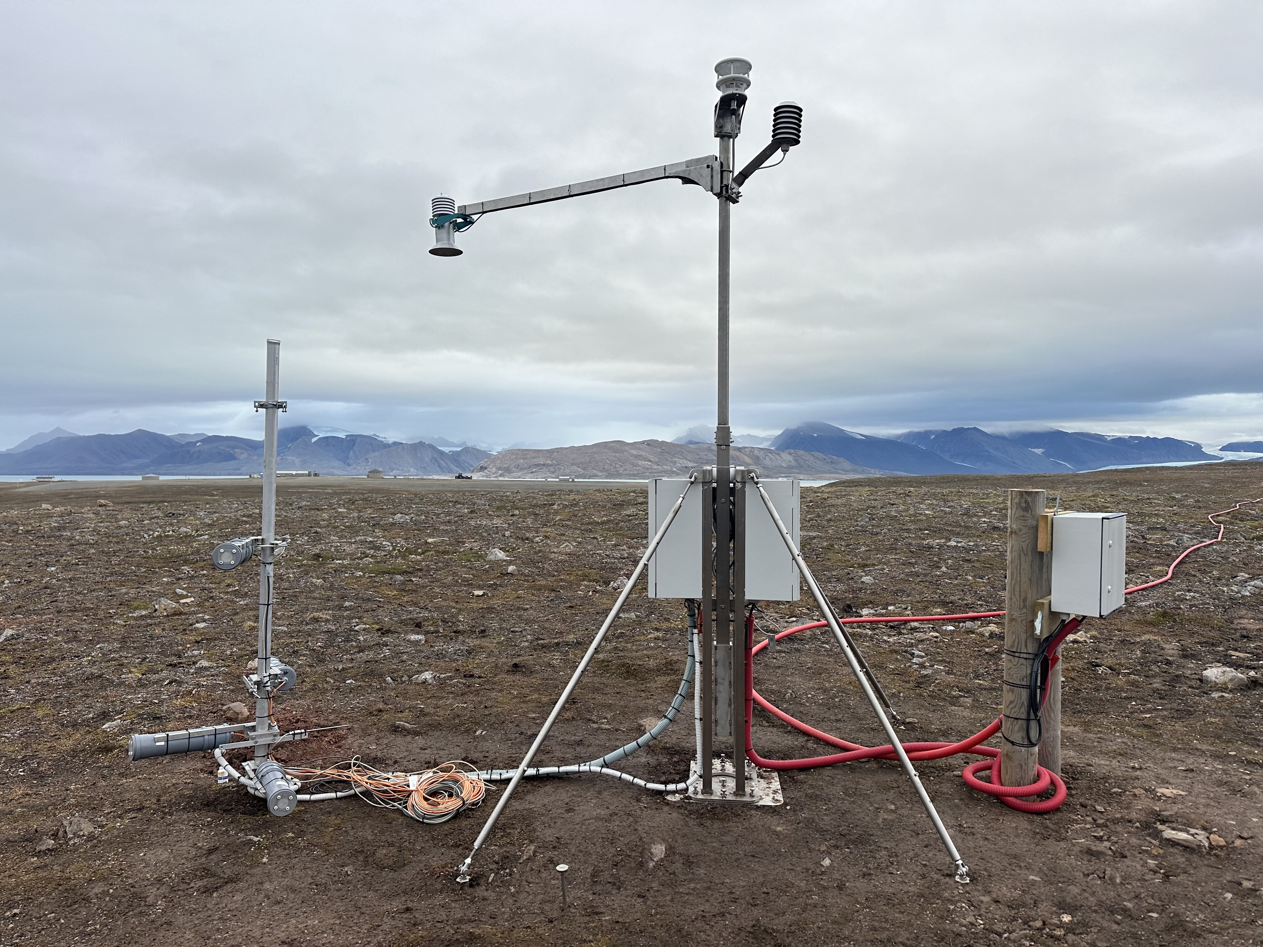
Data refers to the CNR-IGG eddy covariance (EC) facility at the Arctic CZO (Critical Zone Observatory, hereafter CZO@Bayelva in Ny Ålesund). Data have been collected since 2019, all year long, with some interruptions due to ordinary or factory maintenance. The EC tower was installed to study CO2, H20, latent and sensible heat exchanges between soil, vegetation, and atmosphere. Carbon dioxide fluxes and environmental variables are recorded to estimate changes in carbon storage and explore CO2 fluxes drivers in the Arctic tundra. Measured parameters: Net vertical turbulent CO2 flux (umol+1s-1m-2); air temperature (deg_C), air relative humidity (%), wind speed (m+1s-1), max wind speed (m+1s-1), wind direction (deg_from_north). Method: The EC station respects both sensors and data processing standards defined by the ICOS community even if it is not an ICOS-associated station. Flux processing software: EddyPro set to default processing settings. The output variables have a 30-minutes resolution. The parameters available here are obtained by aggregating over a 3-hours time span. The associated measurement time (column B in the uploaded file) indicates the beginning of the 3-hour averaging period (es. Time T= [Time T; Time T+2h30 min]). Instrumentation: 3-Dimensional Sonic Anemometer (Manufacturer: Gill HS-50, s.n.: H183304, Firmware: 3.01, Instrument height: (info in the yearly metadata), North alignment: SPAR, North offset: (info in the yearly metadata), Wind data format: u, v, w); Enclosed path CO2/H2O Gas Analyzer (Licor Li7200RS, s.n.: 72H-0888, Firmware: (info in the yearly metadata), Tube length: 105.8 cm, Tube diameter: 5.33 mm, Northward separation: (info in the yearly metadata), Eastward separation: (info in the yearly metadata), Vertical separation: (info in the yearly metadata)). Quality assurance: Mauder and Foken (2004) flagging policy (0-1-2 system). Here, only high-quality data are reported (qc=0). The CNR-IGG Researchers took the photo of the eddy covariance during the field campaign.
-
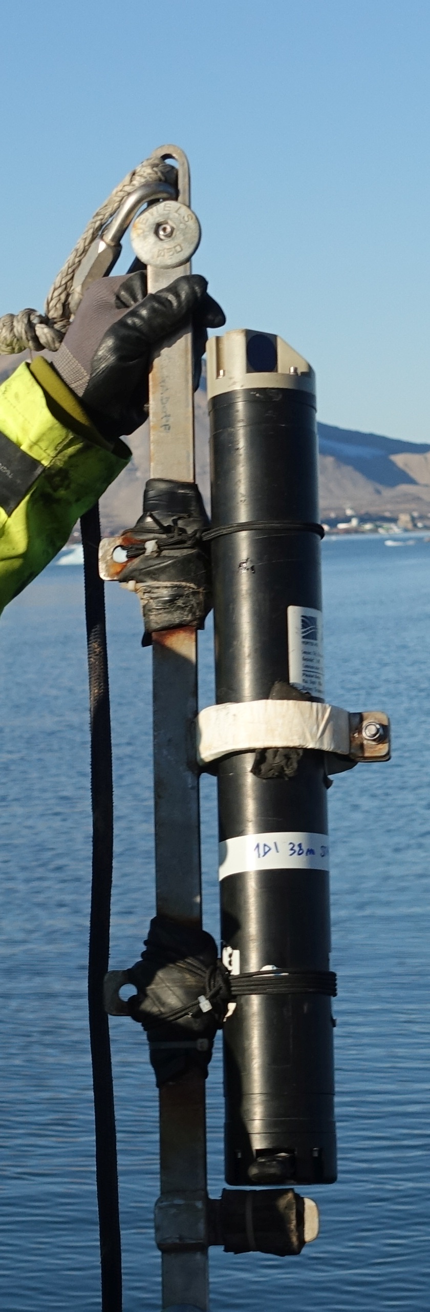
This dataset comprises measurements from a moored single-point acoustic current meter, collected by the Mooring Dirigibile Italia (MDI), which is managed by the Institute of Polar Sciences of the National Research Council (CNR). The data was gathered at Kongsfjorden, Svalbard Island, since 10 September 2010. This dataset is also part of the SIOS-Svalbard Integrated Arctic Earth Observing System, developed to observe the impacts of climate change, including the rapid loss of sea ice cover, the retreat of local glaciers, and the Atlantification of Arctic seas. Measured properties are: subsurface temperature and subsurface currents. The acquisition of this time series data is still ongoing and will continue, bolstered by the inclusion of this infrastructure within the framework of the Italian PNRR project ITINERIS. This ensures sustained data collection and further enhances our understanding of the observed environmental changes.
-
Data collected by the WINTER-CZ Monitoring Station. The CO2 and the temperature is sampled is measured inside the soil, the snowpack (when the station is covered by the snow) and the atmosphere. Other variables are collected as well: the humidity and the oxygen content of the soil, the snowpack height, the humidity and the temperature of the air, the wind speed and direction.