ERDDAP
Type of resources
Available actions
IADC Research Activities
Topics
Keywords
Contact for the resource
Provided by
Years
Formats
Representation types
Update frequencies
status
Scale
-
Aerosol Optical Depth (AOD) measured by the NOrwegian Institute for Air Research (NILU) at Ny-Alesund between 2002 and 2010 by using a Precision Filter Radiometer (PFR). AOD is provided at 500 nm and alpha in the spectral range (nm) 411.9-862.5.
-

Reflectance measurements - CCT. This dataset contains spectral reflectance measurements collected in situ during the peak of the summer growing season (July) for Bistorta vivipara, Cassiope tetragona, Oxyria digyna, Saxifraga oppositifolia, Carex rupestris, Dryas octopetala, and Salix polaris. Reflectance data are fundamental for assessing the optical properties of the vegetation and deriving key spectral indices (e.g., Normalized Difference Vegetation Index (NDVI), PRI).
-

2022 NAIS at Gruvebadet
-
Conductivity, Temperature, Depth (CTD), Salinity, Dissolved Oxygen, Fluorescence, and Turbidity. Vertical profiles averaged every 1 meter along the zonal transect at 75°N. Project PRA CASSANDRA. Italian National Research Council - Institute of Polar Sciences data from a local source. Data originator is the National Institute of Oceanography and Applied Geophysics, OGS, Trieste, Italy.
-

This dataset compiles measurements of gas exchange and associated microclimatic conditions for two dominant dwarf shrub species (Dryas octopetala and Salix polaris) and bare soil control plots. It is important to note that the presented data do not derive from continuous monitoring (e.g., Eddy Covariance) but consist of point (instantaneous) measurements conducted manually during the peak of the summer growing season (July) between 2021 and 2024.
-
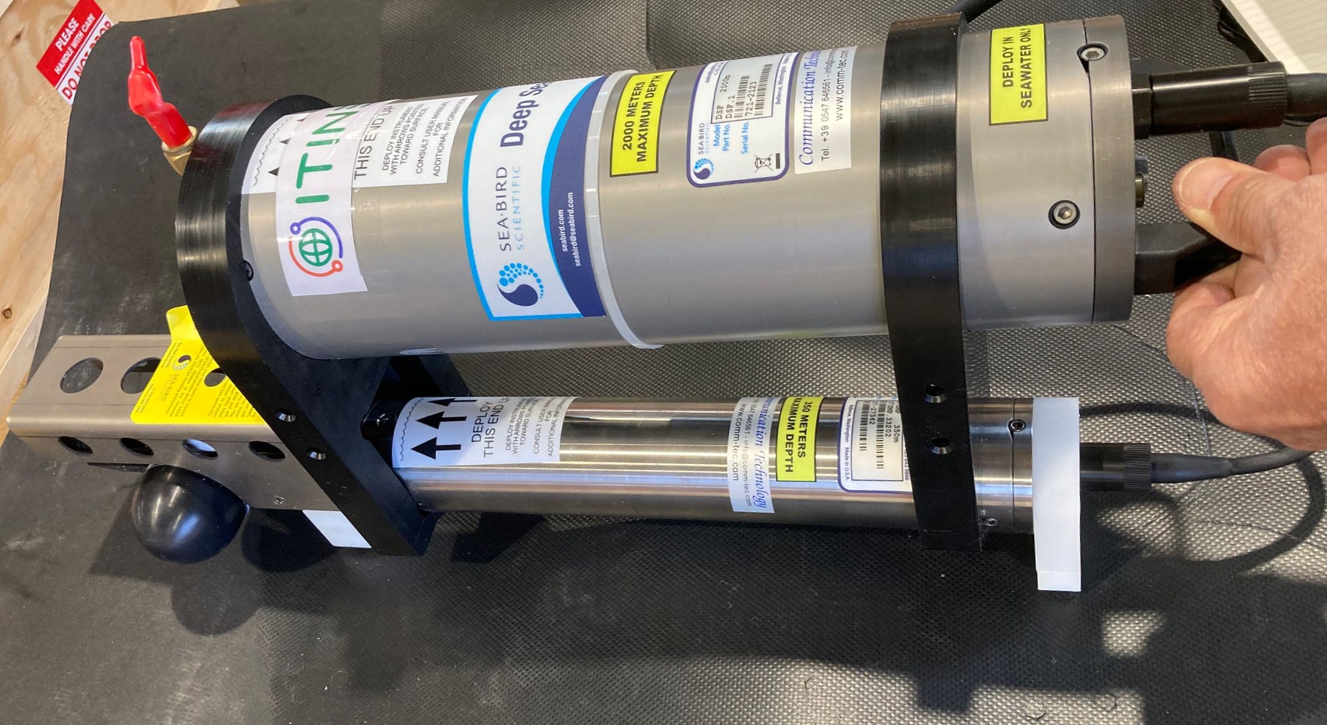
This dataset comprises measurements from thermistor (SBE56) mounted on the Mooring Dirigibile Italia (MDI), which is managed by the Institute of Polar Sciences of the National Research Council (CNR). The mooring is placed in the Kongsfjorden, Svalbard Island, since September 2010 and the thermistor is placed at the nominal depths between 51 and 59 m and is operative from September 2012. This dataset is also part of the SIOS-Svalbard Integrated Arctic Earth Observing System, developed to observe the impacts of climate change, including the rapid loss of sea ice cover, the retreat of local glaciers, and the Atlantification of Arctic seas. Measured properties are: sea-water temperature. The acquisition of this time series data is still ongoing and will continue, bolstered by the inclusion of this infrastructure within the framework of the Italian PNRR project ITINERIS. This ensures sustained data collection and further enhances our understanding of the observed environmental changes.
-

This dataset comprises measurements from moored multiparametric probe, collected by the Aldo Pontremoli Mooring (MAP), which is managed by the Institute of Polar Sciences of the National Research Council (CNR). The Aldo Pontremoli Mooring (MAP), operated by the Institute of Polar Sciences of the National Research Council (CNR), has been active in the Kongsfjord, located in the Svalbard archipelago, since September, 2020. The instrument collect a wide array of physical and biogeochemical Essential Ocean Variables, including velocity and direction of currents. This activity is part of the Svalbard Integrated Arctic Earth Observing System (SIOS), which aims to monitor the impacts of climate change, such as the rapid loss of sea ice cover, the retreat of local glaciers, and the Atlantification of Arctic seas. Time series acquisition is ongoing and will continue, supported by funding from JRA ENI-CNR. The project's goal is to analyse the environmental feeback related to the material released into the marine environment due to permafrost melting. Reactivated permafrost can have significant consequences for both climate and the environment by contributing to the release of greenhouse gases into the atmosphere and pollutants into aquatic ecosystems
-
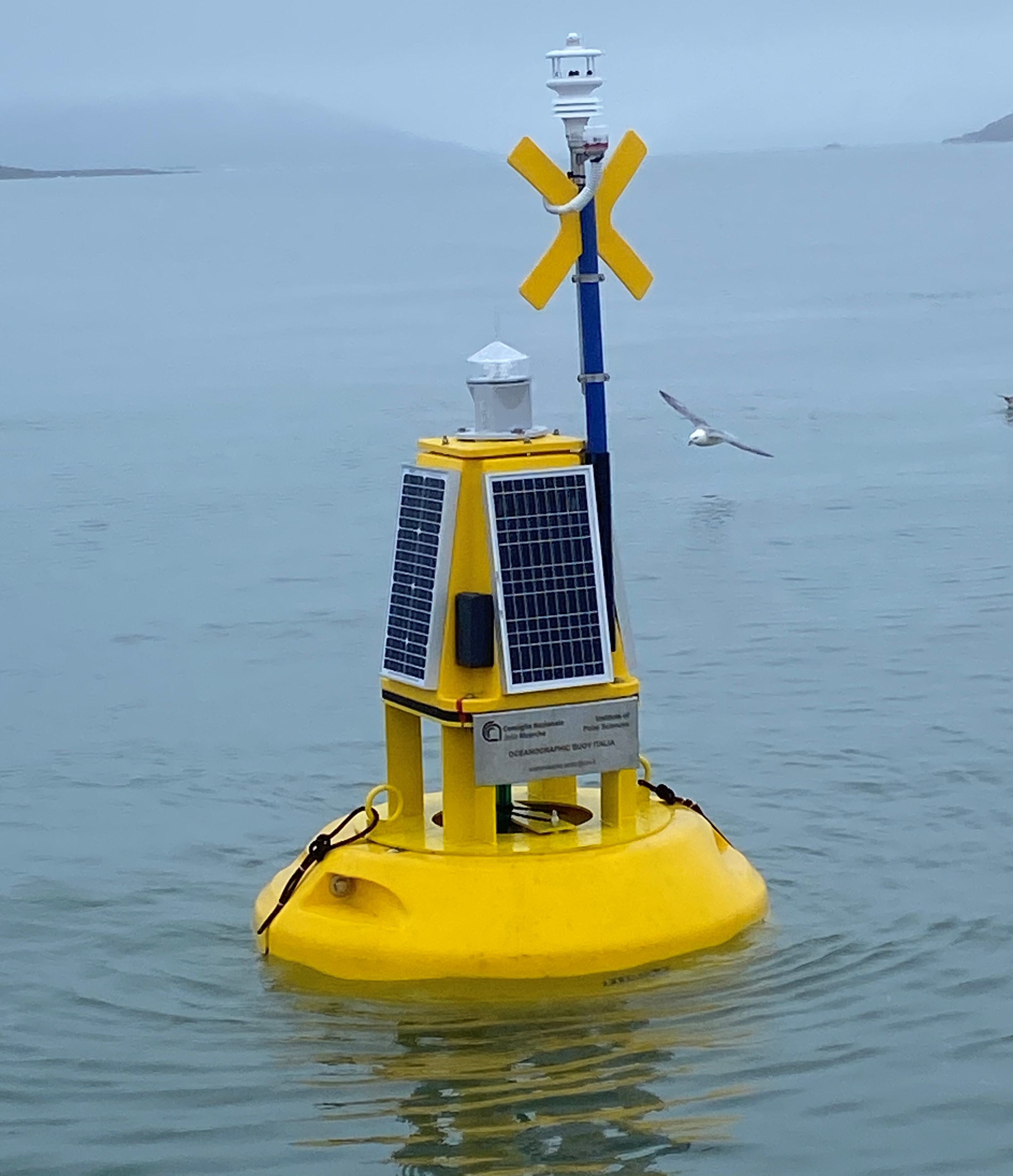
This dataset comprises measurements from moored surface buoy installed in the Kongsfjorden in proximity of the Mooring Dirigibile Italia (MDI). The buoy is managed by the Institute of Polar Sciences of the National Research Council (CNR). The buoy was moored in September 2023 with the aim to expand the observation on the sea-surface layer and also on the athmosphere in the framework of the Italian PNRR project ITINERIS. The buoy is equipped with sea surface temperature sensor positioned at 1m below the sea-level and meteorological station mounted at 2 m above the sea-leve. Mesured properties are seawater temperature, wind speed and direction, air pressure, air temperature, solar radiation and atmospheric humidity.
-

This dataset contains leaf stable isotope (\u03b4\u00b9\u00b3C, \u03b4\u00b9\u2075N) and elemental composition (carbon and nitrogen content, C:N ratio) data for two dominant high-arctic dwarf shrubs, Dryas octopetala L. and Salix polaris Wahlenb. Samples were collected repeatedly during the peak of the growing season (July) from 2021 to 2024 at a continuous permafrost site in the Brogger Peninsula, near Ny-Alesund, Svalbard
-
This dataset comprises measurements from moored multiparametric probe, collected by the Aldo Pontremoli Mooring (MAP), which is managed by the Institute of Polar Sciences of the National Research Council (CNR). The Aldo Pontremoli Mooring (MAP), operated by the Institute of Polar Sciences of the National Research Council (CNR), has been active in the Kongsfjord, located in the Svalbard archipelago, since September, 2020. The instrument collect a wide array of physical and biogeochemical Essential Ocean Variables, including seawater pressure, temperature, conductivity, salinity, dissolved oxygen concentration and pH. This activity is part of the Svalbard Integrated Arctic Earth Observing System (SIOS), which aims to monitor the impacts of climate change, such as the rapid loss of sea ice cover, the retreat of local glaciers, and the Atlantification of Arctic seas. Time series acquisition is ongoing and will continue, supported by funding from JRA ENI-CNR. The project's goal is to analyse the environmental feeback related to the material released into the marine environment due to permafrost melting. Reactivated permafrost can have significant consequences for both climate and the environment by contributing to the release of greenhouse gases into the atmosphere and pollutants into aquatic ecosystems