BOA ITALIA measurements in the Kongsfjorden (MDI site)
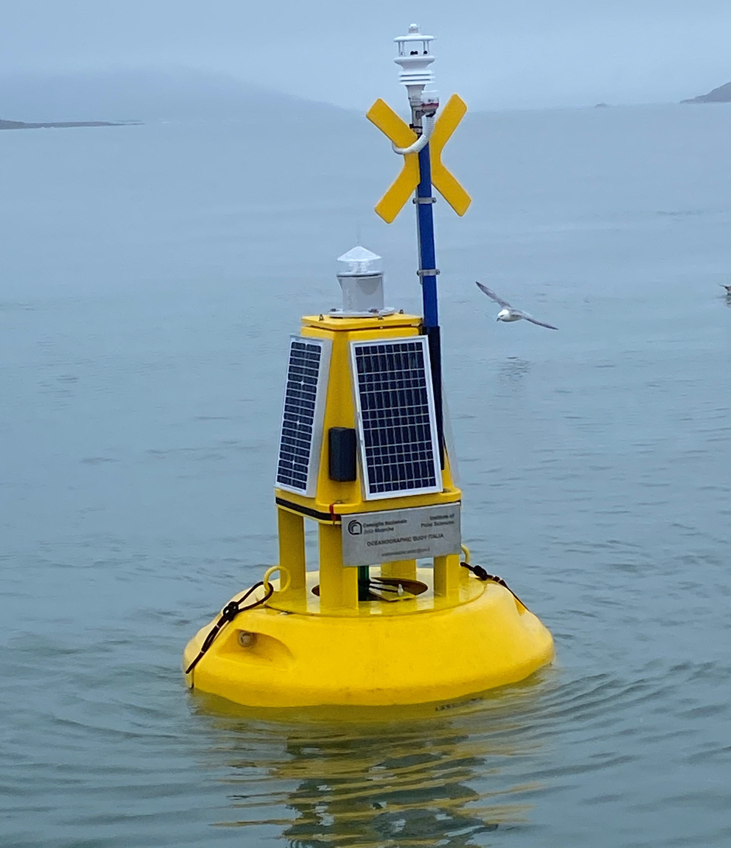
This dataset comprises measurements from moored surface buoy installed in the Kongsfjorden in proximity of the Mooring Dirigibile Italia (MDI). The buoy is managed by the Institute of Polar Sciences of the National Research Council (CNR). The buoy was moored in September 2023 with the aim to expand the observation on the sea-surface layer and also on the athmosphere in the framework of the Italian PNRR project ITINERIS. The buoy is equipped with sea surface temperature sensor positioned at 1m below the sea-level and meteorological station mounted at 2 m above the sea-leve. Mesured properties are seawater temperature, wind speed and direction, air pressure, air temperature, solar radiation and atmospheric humidity.
Simple
- Date (Creation)
- 2025-03-04
- Date (Publication)
- 2025-03-04
- Identifier
- https://metadata.iadc.cnr.it/geonetwork/srv/api/records/5d3ea481-87c5-42a3-9e12-6d7e87e550e6
- Status
- Historical archive
- Maintenance and update frequency
- Not planned
- Keywords
-
-
time, time, latitude, longitude, sea_surface_temperature, air_temperature, wind_from_direction, air_pressure, relative_humidity
-
- Use limitation
- Creative-Commons CC BY-NC-SA 4.0
- Spatial representation type
- Text, table
- Denominator
- 1
- Metadata language
- English
- Topic category
-
- Oceans
))
- Begin date
- 2023-09-07T04:15:05Z
- End date
- 2024-01-08T20:15:05Z
- Unique resource identifier
- WGS84
- Distribution format
-
-
ERDDAP
()
-
ERDDAP
()
- OnLine resource
-
Landing page
(
WWW:LINK-1.0-http--link
)
Metadata landing page
- OnLine resource
-
ERDDAP link to dataset
(
WWW:LINK-1.0-http--opendap
)
Link to ERDDAP
- OnLine resource
-
Direct download
(
WWW:DOWNLOAD-1.0-http--download
)
Download a NETCDF version
- OnLine resource
-
Buoy installation CNR press release
(
WWW:LINK-1.0-http--link
)
CNR press release about the installation of the buoy
- OnLine resource
- Digital Object Identifier (DOI) ( DOI )
- Hierarchy level
- Dataset
Domain consistency
Conformance result
- Date (Publication)
- 2010-12-08
- Explanation
-
This data set is conformant with the INSPIRE Implementing Rules for the interoperability of spatial data sets and services
- Pass
- Yes
- Statement
-
Observation activities in the Kongsfjord since 2010 and first attempt of a moored surface buoy with Near Real Time trasmission
- File identifier
- 5d3ea481-87c5-42a3-9e12-6d7e87e550e6 XML
- Metadata language
- English
- Character set
- UTF8
- Hierarchy level
- Dataset
- Date stamp
- 2026-04-08T14:30:45
- Metadata standard name
-
ISO 19139
- Metadata standard version
-
1.0
Overviews
Spatial extent
Provided by