MAP Mooring
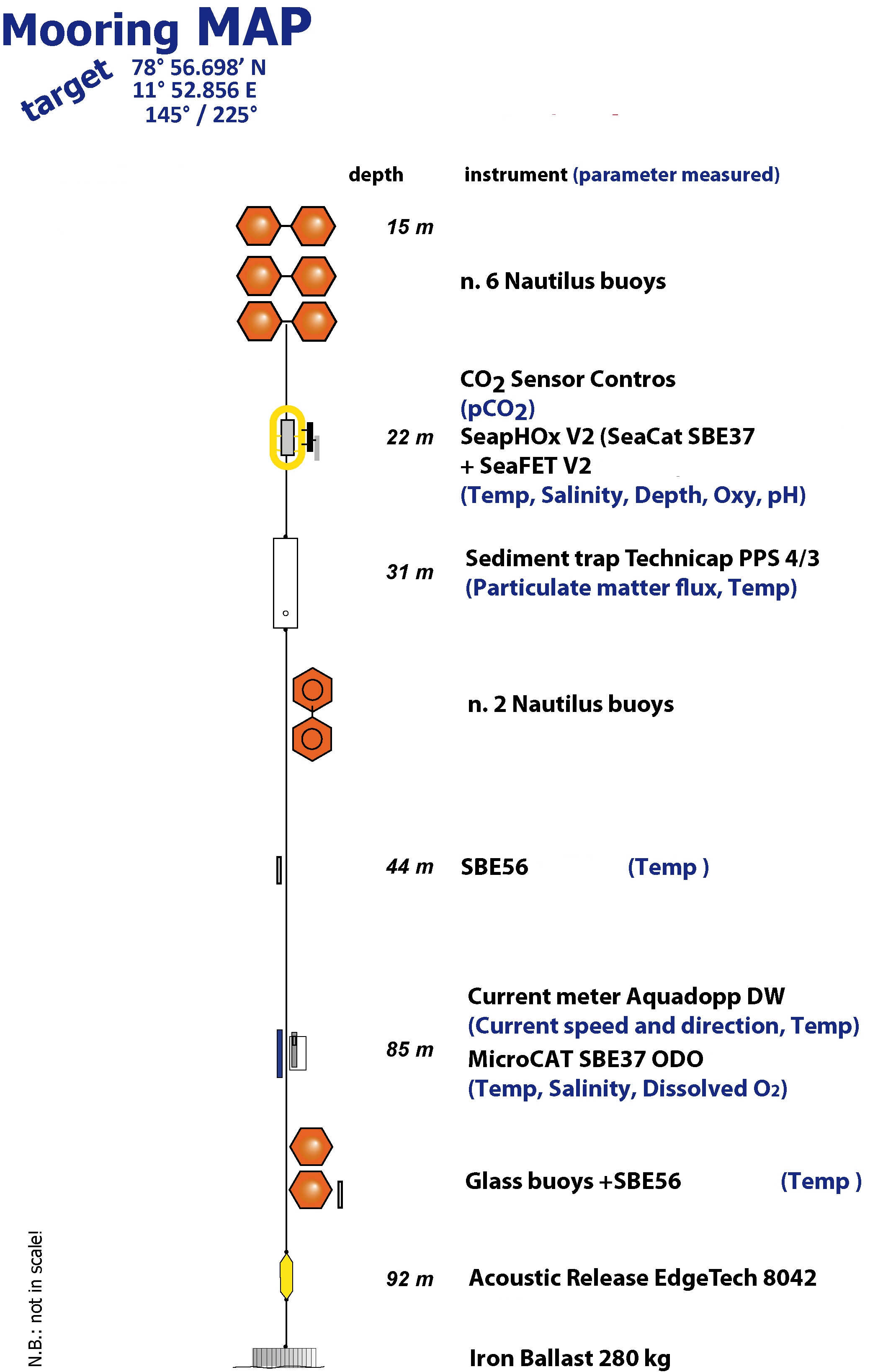
The Aldo Pontremoli Mooring (MAP), operated by the Institute of Polar Sciences of the National Research Council (CNR), has been active in the Kongsfjord, located in the Svalbard archipelago, since September 11, 2020. It is situated near the mouth of Bayelva River mouth and is influenced by land terminating glaciers and the release of permafrost. Currently, the mooring line is equipped with various instruments positioned at depths ranging from 22 to 97 meters within the water column. These instruments collect a wide array of physical and biogeochemical Essential Ocean Variables, including seawater pressure, temperature, conductivity, salinity, currents, dissolved oxygen concentration, pH, particle fluxes and dissolved carbon dioxide concentration. This activity is part of the Svalbard Integrated Arctic Earth Observing System (SIOS), which aims to monitor the impacts of climate change, such as the rapid loss of sea ice cover, the retreat of local glaciers, and the Atlantification of Arctic seas. Time series acquisition is ongoing and will continue, supported by funding from JRA ENI-CNR. The project's goal is to analyse the environmental feeback related to the material released into the marine environment due to permafrost melting. Reactivated permafrost can have significant consequences for both climate and the environment by contributing to the release of greenhouse gases into the atmosphere and pollutants into aquatic ecosystems.
Simple
- Date (Creation)
- 2021-10-01T00:00:00
- Identifier
- https://metadata.iadc.cnr.it/geonetwork/srv/api/records/9bce1f64-c4e5-4d5b-b5a0-13644f8c5260
- Credit
-
JRA ENI-CNR
- Status
- On going
- Maintenance and update frequency
- Annually
- Theme
-
-
GEMET - INSPIRE themes, version 1.0
-
-
Environmental monitoring facilities
-
Hydrography
-
-
GCMD - Science Keywords
-
-
WATER TEMPERATURE
-
OXYGEN
-
SALINITY
-
PARTICLE FLUX
-
COASTAL PROCESSES
-
-
GCMD - Instruments
-
-
TEMPERATURE SENSORS
-
-
GCMD - Locations
-
-
SVALBARD AND JAN MAYEN
-
ARCTIC
-
-
GCMD - Providers
-
-
ITALY
-
-
IADC Research Activities
-
-
Marine and oceanographic research
-
- Use limitation
- Creative-Commons CC BY-4.0
- Unique resource identifier
- IADC Italian Arctic Data Center
- Association Type
- dependency
- Initiative Type
- Project
- Spatial representation type
- Text, table
- Denominator
- 1
- Metadata language
- English
- Topic category
-
- Oceans
))
- Begin date
- 2020-09-11
- End date
- 2030-12-31 Now
- Unique resource identifier
- WGS84
- Distribution format
-
-
Excel
(
1
)
-
Excel
(
1
)
- OnLine resource
- Landing page ( WWW:LINK-1.0-http--link )
- OnLine resource
-
Link to JRA ENI-CNR project description
(
WWW:LINK-1.0-http--link
)
Description of the project
- OnLine resource
- MAP Mooring CTD and SeaFet data at 20m ( WWW:LINK-1.0-http--related )
- OnLine resource
- MAP Mooring CTD data @ 35m ( WWW:LINK-1.0-http--related )
- OnLine resource
- MAP mooring Aquadopp data at 35m ( WWW:LINK-1.0-http--related )
- OnLine resource
- MAP Mooring T data @ 40m ( WWW:LINK-1.0-http--related )
- Hierarchy level
- Dataset
Domain consistency
Conformance result
- Date (Publication)
- 2010-12-08
- Explanation
-
This data set is conformant with the INSPIRE Implementing Rules for the interoperability of spatial data sets and services
- Pass
- Yes
- Statement
-
Time series acquisition of biogeochemical parameters along the water column along the mooring MAP
- File identifier
- 9bce1f64-c4e5-4d5b-b5a0-13644f8c5260 XML
- Metadata language
- English
- Character set
- UTF8
- Hierarchy level
- Dataset
- Date stamp
- 2026-07-09T14:24:32
- Metadata standard name
-
ISO 19139
- Metadata standard version
-
1.0
Overviews
Spatial extent
Provided by