KIM Mooring
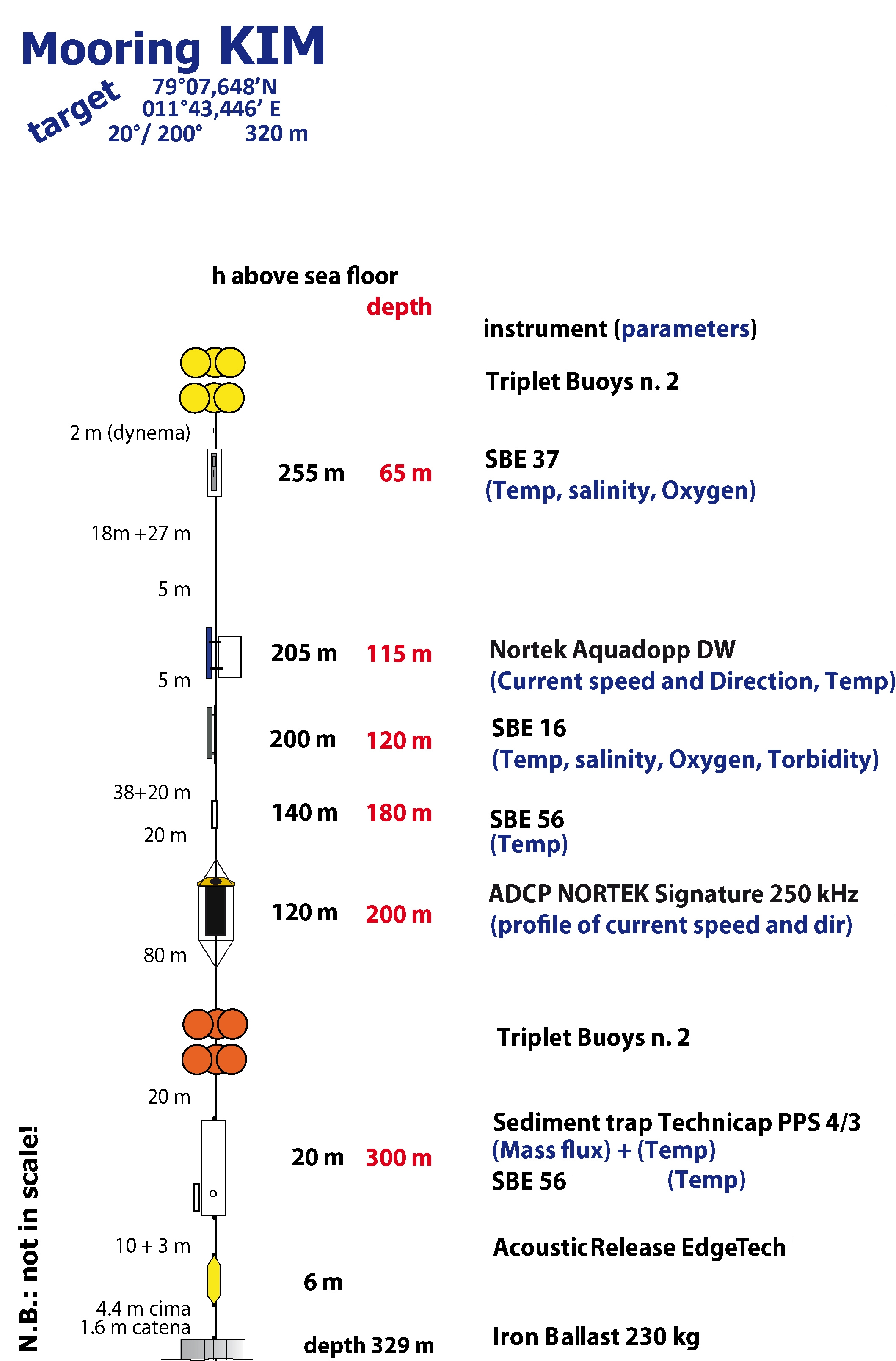
The Krossfjord Italian Mooring (KIM), operated by the Institute of Polar Sciences of the National Research Council (CNR), has been active in the Krossfjord of the Svalbard archipelago since September 9, 2020. The mooring line is equipped with various instruments placed at depths ranging from 65 to 300 meters in the water column. These instruments collect a wide range of physical and biogeochemical Essential Ocean Variables, including seawater pressure, temperature, conductivity, currents, dissolved oxygen concentration, turbidity, particle fluxes and ocean sound. This activity is part of the SIOS (Svalbard Integrated Arctic Earth Observing System), designed to monitor the impacts of climate change, such as the rapid loss of sea ice cover, the retreat of local glaciers, and the Atlantification of Arctic seas. Time series acquisition is ongoing and will continue, supported by the integration of this infrastructure into the Italian Marine Data Portal, developed under the ITINERIS PNRR project. This project also funds the enhancement of the research infrastructure with new sensors to improve measurement resolution, expand the number of EOVs measured, and support the continuous collection of long-term data. These efforts will further deepen our understanding of the observed environmental changes.
Simple
- Date (Creation)
- 2021-10-01T00:00:00
- Identifier
- https://metadata.iadc.cnr.it/geonetwork/srv/api/records/47a45503-25a5-44e9-9192-e98d0fe25e63
- Credit
-
NextGenerationEU;ITINERIS; Italian Integrated Environmental Research Infrastructures System;IR0000032
- Status
- On going
- Maintenance and update frequency
- Annually
- Theme
-
-
Marine and oceanographic research
-
GEMET - INSPIRE themes, version 1.0
-
-
Hydrography
-
Environmental monitoring facilities
-
-
GCMD - Science Keywords
-
-
SALINITY
-
WATER TEMPERATURE
-
PARTICLE FLUX
-
OXYGEN
-
COASTAL PROCESSES
-
-
GCMD - Instruments
-
-
TEMPERATURE SENSORS
-
-
GCMD - Locations
-
-
SVALBARD AND JAN MAYEN
-
ARCTIC
-
-
GCMD - Providers
-
-
ITALY
-
-
IADC ID
-
-
IADC_ID_20
-
IADC_ID_797
-
-
IADC Research Activities 2
-
-
Oceanographic and marine research
-
Marine biology and biodiversity
-
- Use limitation
- Creative-Commons CC BY-4.0
- Unique resource identifier
- IADC Italian Arctic Data Center
- Association Type
- dependency
- Initiative Type
- Project
- Spatial representation type
- Text, table
- Denominator
- 1
- Metadata language
- English
- Topic category
-
- Oceans
))
- Begin date
- 2020-09-01
- End date
- 2034-08-31 Now
- Unique resource identifier
- WGS84
- Distribution format
-
-
Excel
(
1
)
-
Excel
(
1
)
- OnLine resource
- Landing page ( WWW:LINK-1.0-http--link )
- OnLine resource
- RIS Project ( WWW:LINK-1.0-http--link )
- OnLine resource
-
KIM Mooring CTD data @ 65m
(
WWW:LINK-1.0-http--opendap
)
Link to ERDDAP
- OnLine resource
-
KIM Mooring Aquadopp data @ 115m
(
WWW:LINK-1.0-http--opendap
)
Link to ERDDAP
- OnLine resource
-
KIM Mooring CTD data @ 120m
(
WWW:LINK-1.0-http--opendap
)
Link to ERDDAP
- OnLine resource
-
KIM Mooring T data @ 180m
(
WWW:LINK-1.0-http--opendap
)
Link to ERDDAP
- OnLine resource
-
KIM Mooring ADCP data @ 200m
(
WWW:LINK-1.0-http--opendap
)
Link to ERDDAP
- OnLine resource
-
KIM Mooring T data @ 300m
(
WWW:LINK-1.0-http--opendap
)
Link to ERDDAP
- Hierarchy level
- Dataset
Domain consistency
Conformance result
- Date (Publication)
- 2010-12-08
- Explanation
-
This data set is conformant with the INSPIRE Implementing Rules for the interoperability of spatial data sets and services
- Pass
- Yes
- Statement
-
Time series acquisition of ADCP current meter data at mooring station MDI.
- File identifier
- 47a45503-25a5-44e9-9192-e98d0fe25e63 XML
- Metadata language
- English
- Character set
- UTF8
- Hierarchy level
- Dataset
- Date stamp
- 2026-07-09T14:22:29
- Metadata standard name
-
ISO 19139
- Metadata standard version
-
1.0
Overviews
Spatial extent
Provided by