MDI Mooring CTD data at 89m
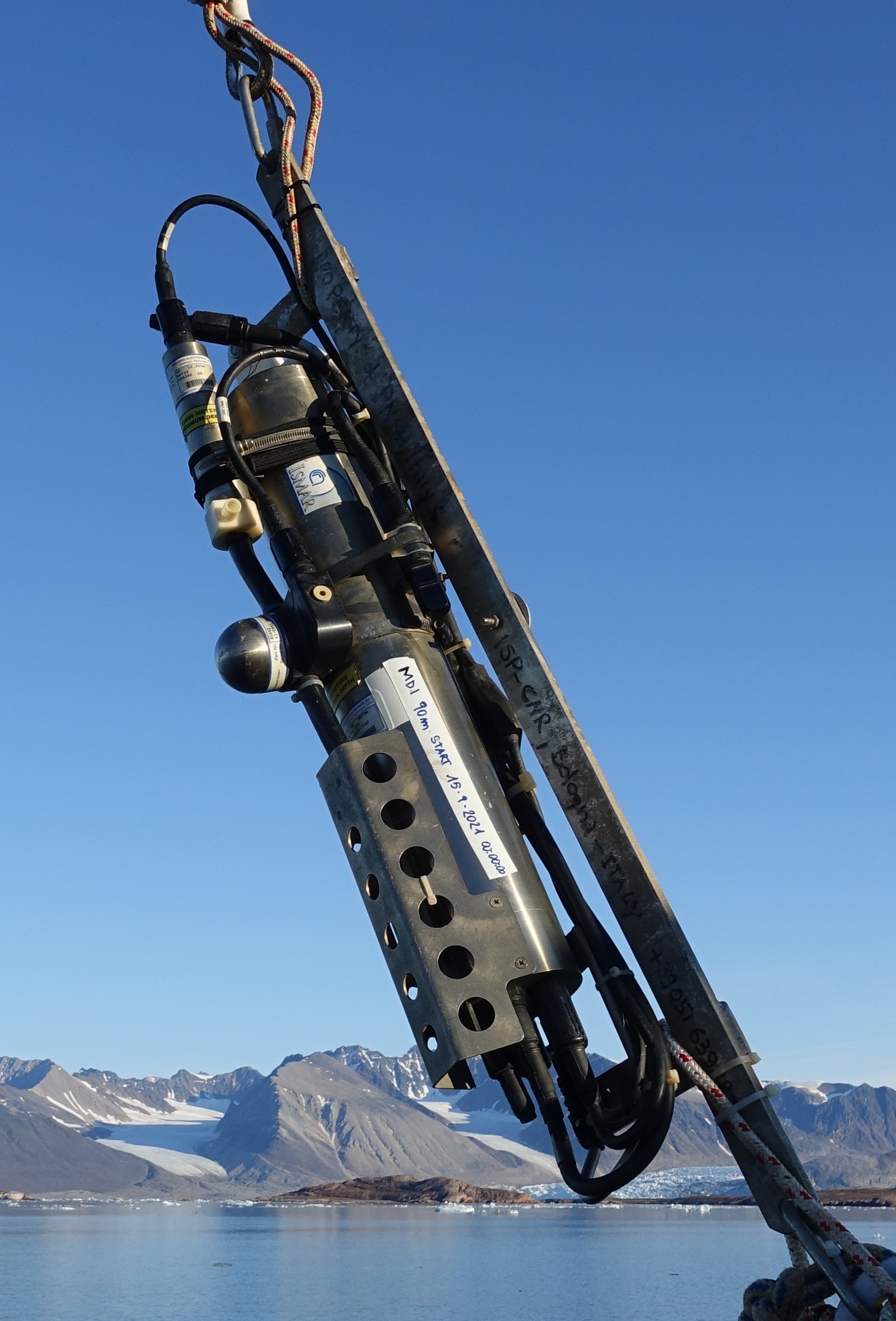
This dataset comprises measurements from moored CTD instruments, collected by the Mooring Dirigibile Italia (MDI), which is managed by the Institute of Polar Sciences of the National Research Council (CNR). The data was gathered at Kongsfjorden, Svalbard Island, since 9 September 2010. This dataset is also part of the SIOS-Svalbard Integrated Arctic Earth Observing System, developed to observe the impacts of climate change, including the rapid loss of sea ice cover, the retreat of local glaciers, and the Atlantification of Arctic seas. Measured properties are: sea-water pressure, subsurface temperature, conductivity, dissolved oxygen in sea-water and turbidity. The acquisition of this time series data is still ongoing and will continue, bolstered by the inclusion of this infrastructure within the framework of the Italian PNRR project ITINERIS. This ensures sustained data collection and further enhances our understanding of the observed environmental changes.
Simple
- Date (Creation)
- 2024-06-04
- Identifier
- https://doi.org/10.53132/CNR-ISP.2024.DAT.GCC.OCE.ART.54
- Credit
-
NextGenerationEU;ITINERIS; Italian Integrated Environmental Research Infrastructures System;IR0000032
- Status
- On going
- Maintenance and update frequency
- Annually
- Keywords
-
-
time, latitude, longitude, depth, sea_water_pressure, sea_water_temperature, sea_water_potential_temperature, sea_water_salinity, sea_water_density, mass_concentration_of_oxygen_in_sea_water, sea_water_turbidity
-
-
GCMD - Science Keywords
-
-
OCEAN PRESSURE
-
OCEAN SALINITY RECONSTRUCTION
-
OCEAN TEMPERATURE
-
TURBIDITY
-
DISSOLVED OXYGEN
-
-
IADC ID
-
-
IADC_ID_797
-
- Theme
-
-
IADC Research Activities 2
-
-
Marine biology and biodiversity
-
- Use limitation
- Creative-Commons CC BY-NC-SA 4.0
- Spatial representation type
- Text, table
- Denominator
- 1
- Metadata language
- English
- Topic category
-
- Oceans
))
- Begin date
- 2010-09-09T00:00:00Z
- End date
- 2024-08-31T00:00:00Z
- OnLine resource
-
Link to NetCDF files
(
WWW:LINK-1.0-http--link
)
Download a NetCDF version
- OnLine resource
-
ERDDAP link to dataset
(
WWW:LINK-1.0-http--opendap
)
Link to ERDDAP
- OnLine resource
-
Mooring activity description
(
WWW:LINK-1.0-http--link
)
Web page of CNR ISP describing observatory activity in Svalbard region
- OnLine resource
- Digital Object Indentifier (DOI) ( DOI )
- Hierarchy level
- Dataset
Domain consistency
Conformance result
- Date (Publication)
- 2010-12-08
- Explanation
-
This data set is conformant with the INSPIRE Implementing Rules for the interoperability of spatial data sets and services
- Pass
- Yes
- Statement
-
moorings activities in the Kongsfjord since 2010
- File identifier
- aa793636-94bb-4c57-8480-1cb0e5af6296 XML
- Metadata language
- English
- Character set
- UTF8
- Date stamp
- 2026-05-04T11:45:43
- Metadata standard name
-
ISO 19139
- Metadata standard version
-
1.0
Overviews
Spatial extent
Provided by